Other local high temps:
ACCU: 63
JESSE: 64
KUNV: 63
Other local high temps:
ACCU: 63
JESSE: 64
KUNV: 63
Other local high temps:
ACCU: 65
JESSE: 66
KUNV: 65
PSU's high for Dec. 14th was 62, tying the record from LAST Year!
Other local high temps:
ACCU: 63
JESSE: 66
KUNV: 65
Other local highs:
ACCU: 75
JESSE: 79
KUNV: 74
Selected* Online Centre County Lows this morning:
Jesse Ferrell: 28
Elliot Abrams: 32
Corl Street:   32
AccuWeather:   33
Marshall Moss: 33
KUNV Airport:  37
PSU Shelter:   39
Penn State did not reach their record of 34.
If your station is not included in this list, please post a comment with your low from this morning.
Other Online Lows This Morning:*

The official PSU temperature stats for the last three winters are shown below; overall, this winter was nearly identical to last winter's departure from normal!
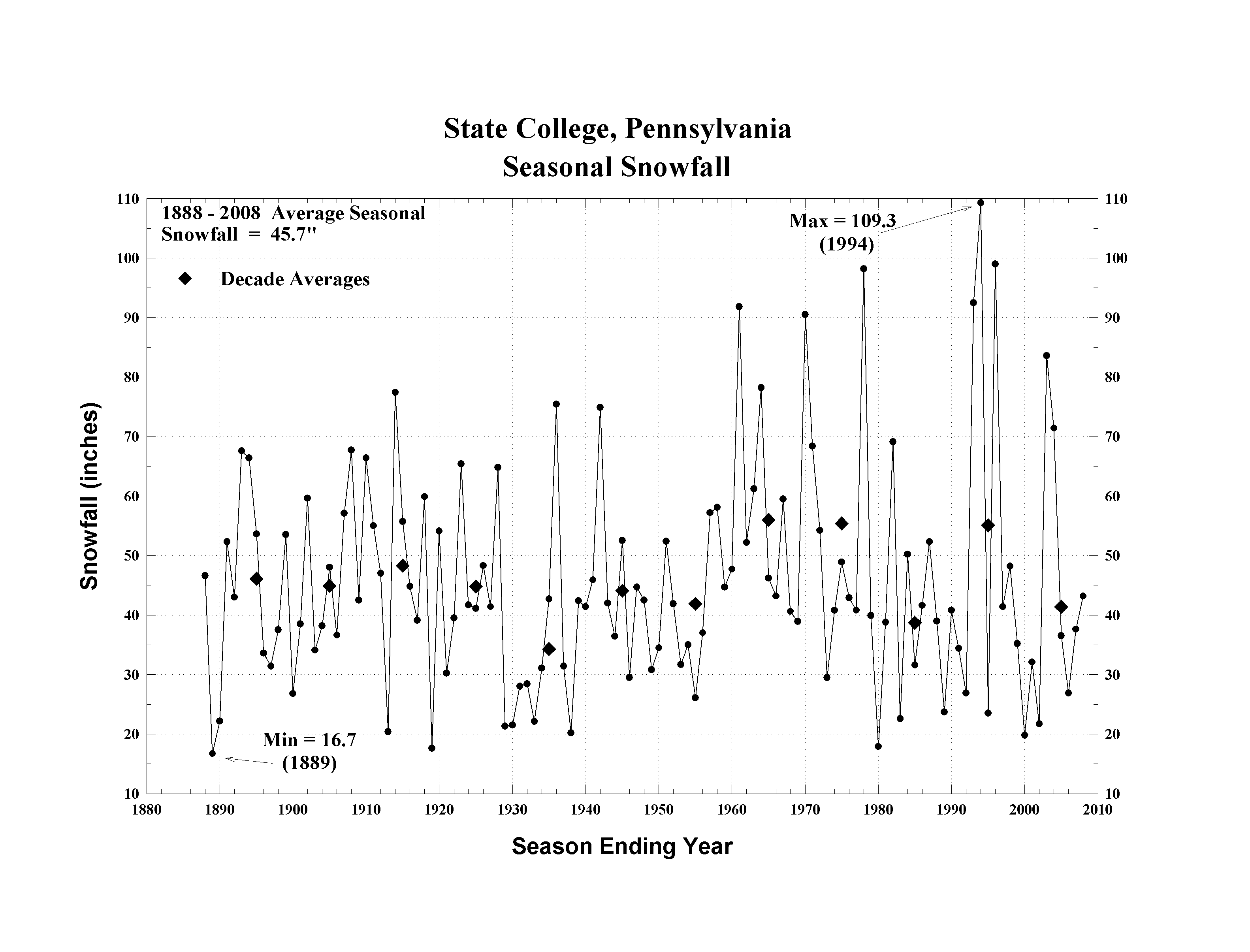
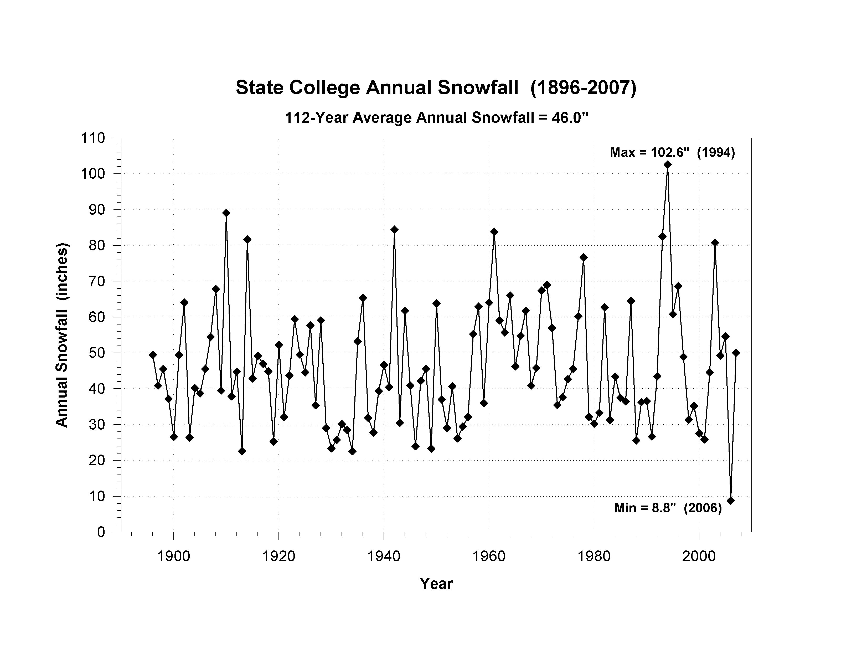
In addition to the temperature record mentioned above, 1994 was quite a winter. Harrisburg had at least 1" of snow on the ground for 71 consecutive days, which established a new record (this year they only had 45 non-consecutive). 1994's streak continued until they had 75 consecutive days, ending on March 20th. At Penn State, however, 1994's snow cover lasted from January 3 to March 31 (88 consecutive days!) And of course, that snow year (July 1993 - June 1994) set the record of 109.3" here in State College (as well as the Annual Snowfall at 102.6").
Selected* Online Centre County Lows this morning:
Jesse Ferrell: -8
AccuWeather:   -3
Elliot Abrams: -3
Marshall Moss: -3
KUNV Airport:   0
PSU Shelter:   +2
I believe my reading of -8 to be a new record for March at my station (since 1997). PSU's temperature of +2 this morning is listed as "#1" in their database for this date. It does not however beat the record low for March of -4, set mid-month. The temperature at a station on Scotia Road also fell to -6.
If your station is not included in this list, please post a comment with your low from this morning.
Other Online Lows This Morning:*

Other State Lows This Morning:
UPDATE: Harrisburg's readings this morning and Saturday morning were 2 & 3 @ CXY, and 0 & -1 at MDT. All these established new daily records, and the lower readings were also new records for March.
Selected* Online Centre County Lows this morning:
Jesse Ferrell: -16*
Elliot Abrams: -10
Corl Street:   -10*
AccuWeather:   -9*
KUNV Airport:  -8
PSU Shelter:   -5
PSU WalkerTop: -2
My reading of -16 is the lowest temperature at my station (>1997). I believe this is also the case for Corl Street (>2010) and AccuWeather (>2005). PSU's temperature of -5 for 2/25 is listed as "#1" in their database for this date.
If your station is not included in this list, please post a comment with your low from this morning.
Other Online Lows This Morning:*

The state low was -26 at Johnsonburg. Other State Lows This Morning <=10 (NWS):
...LOW TEMPERATURE REPORTS...


LOCATION                     TEMP      TIME/DATE       LAT/LON


...BEDFORD COUNTY...

1 ENE QUEEN                  -14 F     0530 AM 02/24   40.26N/78.49W


...BLAIR COUNTY...

1 WNW TYRONE                 -13 F     0649 AM 02/24   40.68N/78.26W

2 NW SHY BEAVER              -12 F     0705 AM 02/24   40.32N/78.24W


...CAMBRIA COUNTY...

EBENSBURG                    -18 F     0800 AM 02/24   40.47N/78.73W

COLVER                       -12 F     0239 AM 02/24   40.54N/78.79W

2 N SOUTH FORK               -11 F     0730 AM 02/24   40.40N/78.80W


...CAMERON COUNTY...

1 ESE EMPORIUM               -17 F     0623 AM 02/24   41.51N/78.21W

2 ESE STEVENSON DAM          -16 F     0635 AM 02/24   41.41N/78.02W

2 WSW CAMERON                -16 F     0259 AM 02/24   41.42N/78.19W


...CENTRE COUNTY...

1 ENE MILLHEIM               -15 F     0653 AM 02/24   40.90N/77.46W

1 ENE ROCK SPRINGS           -15 F     0618 AM 02/24   40.73N/77.94W

2 SW STATE COLLEGE           -15 F     0532 AM 02/24   40.77N/77.88W

3 SE UNIONVILLE              -14 F     0622 AM 02/24   40.87N/77.85W

2 WNW PARK FOREST            -14 F     0635 AM 02/24   40.81N/77.94W

2 E PORT MATILDA             -13 F     0553 AM 02/24   40.79N/78.01W

PARK FOREST                  -12 F     0520 AM 02/24   40.79N/77.91W

2 S PHILIPSBURG              -11 F     0700 AM 02/24   40.87N/78.22W

PARK FOREST                  -11 F     0656 AM 02/24   40.80N/77.92W


...CLEARFIELD COUNTY...

CLEARFIELD-LAWRENCE AIRPORT  -18 F     0642 AM 02/24   41.05N/78.41W


...CLINTON COUNTY...

1 E KETTLE CREEK STATE PARK  -13 F     0600 AM 02/24   41.36N/77.92W

LOGANTON                     -13 F     0629 AM 02/24   41.04N/77.29W

RENOVO                       -12 F     0700 AM 02/24   41.33N/77.73W

1 NW MILL HALL               -11 F     0658 AM 02/24   41.12N/77.51W

...COLUMBIA COUNTY...

3 SSW NEW COLUMBUS           -17 F     0623 AM 02/24   41.13N/76.30W


...ELK COUNTY...

1 NNW JOHNSONBURG            -26 F     0634 AM 02/24   41.50N/78.68W

GLEN HAZEL                   -22 F     0700 AM 02/24   41.57N/78.60W

RIDGWAY                      -21 F     0700 AM 02/24   41.42N/78.75W

1 WSW SAINT MARYS            -21 F     0620 AM 02/24   41.42N/78.58W

RIDGWAY                      -19 F     0530 AM 02/24   41.42N/78.73W


...LYCOMING COUNTY...

CEDAR RUN                    -14 F     0600 AM 02/24   41.52N/77.45W

2 SSE ENGLISH CENTER         -13 F     0600 AM 02/24   41.41N/77.24W

1 E SOUTH WILLIAMSPORT       -11 F     0605 AM 02/24   41.23N/76.98W


...MCKEAN COUNTY...

2 SSE KINZUA BRIDGE STATE PA -28 F     0540 AM 02/24   41.72N/78.56W

1 SSE REW                    -27 F     0519 AM 02/24   41.88N/78.49W

1 NNE KANE                   -23 F     0700 AM 02/24   41.68N/78.80W

1 W BRADFORD                 -22 F     0514 AM 02/24   41.96N/78.66W

3 WSW BRADFORD               -21 F     0444 AM 02/24   41.95N/78.71W

BRADFORD REGIONAL AIRPORT    -20 F     0653 AM 02/24   41.80N/78.64W

4 W BRADFORD                 -16 F     0800 AM 02/24   41.95N/78.73W


...NORTHUMBERLAND COUNTY...

2 NNW MOUNT CARMEL           -11 F     0656 AM 02/24   40.83N/76.42W


...POTTER COUNTY...

3 ESE COUDERSPORT            -23 F     0424 AM 02/24   41.75N/77.95W

COUDERSPORT 1 SW             -22 F     0700 AM 02/24   41.77N/78.04W

COUDERSPORT 7SE              -15 F     0700 AM 02/24   41.74N/77.97W

3 SE COUDERSPORT             -15 F     0703 AM 02/24   41.74N/77.97W

2 NE ULYSSES                 -11 F     0410 AM 02/24   41.92N/77.74W

5 SSW GALETON                -10 F     0608 AM 02/24   41.66N/77.67W


...SOMERSET COUNTY...

MEYERSDALE                   -19 F     0700 AM 02/24   39.82N/79.03W

3 SE SEVEN SPRINGS           -18 F     0600 AM 02/24   39.99N/79.25W

BOSWELL                      -18 F     0700 AM 02/24   40.16N/79.03W

7 NW SOMERSET                -15 F     0542 AM 02/24   40.07N/79.17W

BERLIN                       -14 F     0631 AM 02/24   39.92N/78.95W


...TIOGA COUNTY...

COWANESQUE DAM               -17 F     0700 AM 02/24   42.00N/77.15W

MANSFIELD                    -16 F     0603 AM 02/24   41.81N/77.08W

COWANESQUE DAM               -15 F     0515 AM 02/24   41.98N/77.17W

TIOGA                        -14 F     0700 AM 02/24   41.90N/77.14W

1 ESE WELLSBORO              -14 F     0732 AM 02/24   41.74N/77.29W

2 NNW WESTFIELD              -13 F     0520 AM 02/24   41.96N/77.56W

2 WNW BLOSSBURG              -13 F     0634 AM 02/24   41.70N/77.10W

4 NE CEDAR RUN               -12 F     0716 AM 02/24   41.56N/77.41W


...WARREN COUNTY...

CHANDLERS VALLEY 1SE         -25 F     0700 AM 02/24   41.93N/79.30W

TIDIOUTE                     -21 F     0610 AM 02/24   41.68N/79.40W

1 SE RUSSELL                 -16 F     0507 AM 02/24   41.90N/79.12W

WARREN                       -13 F     0700 AM 02/24   41.85N/79.13W


...YORK COUNTY...

YORK AIRPORT                 -12 F     0653 AM 02/24   39.92N/76.87W


...ALLEGHENY COUNTY...

3 ESE VALENCIA       -15.0   556 AM  2/24  CWOP

2 W HAMPTON TOWNSHIP -13.0   455 AM  2/24  AWS

1 WNW PLUM           -12.0   555 AM  2/24  AWS

3 SW RUSSELLTON      -12.0   627 AM  2/24  CWOP

1 SW HEIDELBERG      -11.0   455 AM  2/24  AWS

1 NW BRACKENRIDGE    -11.0   543 AM  2/24  CWOP

NATRONA              -10.0   700 AM  2/24  CO-OP OBSERVER


...ARMSTRONG COUNTY...

PARKER               -20.0   600 AM  2/24  USARMY-COE

WEST HILLS           -19.0   500 AM  2/24  CWOP

CROOKED CREEK LAKE   -18.0   700 AM  2/24  CO-OP OBSERVER

WEST KITTANNING      -16.0   620 AM  2/24  AWS


...BEAVER COUNTY...

3 E ELLPORT          -13.0   510 AM  2/24  CWOP

1 WNW SOUTH HEIGHTS  -12.0   549 AM  2/24  AWS

BEAVER FALLS         -11.0   519 AM  2/24  AWS


...BUTLER COUNTY...

2 ENE PORTERSVILLE   -22.0   528 AM  2/24  RAWS

1 ESE CONNOQUENESSIN -20.0   608 AM  2/24  CWOP

BUTLER               -18.0   535 AM  2/24  AWOS

HARMONY              -16.0   512 AM  2/24  CWOP

2 NE VALENCIA        -15.0   614 AM  2/24  AWS

FOX RUN              -14.0   455 AM  2/24  CWOP

1 WSW SAXONBURG      -13.0   529 AM  2/24  AWS


...CLARION COUNTY...

NEW BETHLEHEM        -25.0   550 AM  2/24  AWS

COOKSBURG            -21.0   645 AM  2/24  CO-OP OBSERVER

PINEY DAM POOL       -21.0   700 AM  2/24  CO-OP OBSERVER

3 SW CLARION         -20.0   547 AM  2/24  CWOP

FOXBURG              -20.0   525 AM  2/24  AWS

3 ESE STRATTANVILLE  -13.0   515 AM  2/24  AWS


...FOREST COUNTY...

6 SW LYNCH           -17.0   407 AM  2/24  RAWS


...GREENE COUNTY...

5 WNW SPRAGGS        -11.0   610 AM  2/24  AWS


...INDIANA COUNTY...

2 SW BURNSIDE        -16.0   610 AM  2/24  CWOP

7 NE CLYMER          -14.0   507 AM  2/24  CWOP

4 WNW LUCERNE MINES  -14.0   503 AM  2/24  CWOP

JIMMY STEWART FIELD  -13.0   415 AM  2/24  AWOS

3 SE INDIANA         -13.0   700 AM  2/24  CO-OP OBSERVER


...JEFFERSON COUNTY...

1 W PUNXSUTAWNEY     -20.0   535 AM  2/24  CWOP

PUNXSUTAWNEY         -19.0   614 AM  2/24  AWS


...LAWRENCE COUNTY...

1 NE ELLWOOD CITY    -17.0   506 AM  2/24  CWOP

NEW CASTLE AIRPORT   -17.0   556 AM  2/24  AWOS

1 NNE NEW CASTLE     -16.0   505 AM  2/24  AWS

ELLWOOD CITY         -16.0   615 AM  2/24  AWS

2 ENE NEW CASTLE     -12.0   429 AM  2/24  AWS

1 N NEW CASTLE       -12.0   700 AM  2/24  CO-OP OBSERVER


...MERCER COUNTY...

3 WNW JACKSON CENTER -23.0   442 AM  2/24  CWOP

2 W NEW LEBANON      -19.0   502 AM  2/24  CWOP

MERCER               -18.0   445 AM  2/24  AWS

GREENVILLE           -17.0   455 AM  2/24  AWS

4 W GROVE CITY       -15.0   428 AM  2/24  DIGIWX


...VENANGO COUNTY...

SENECA               -18.0   355 AM  2/24  AWS

HASSON HEIGHTS       -18.0   500 AM  2/24  AWS

CLINTONVILLE         -16.0   430 AM  2/24  AWS

CHESS-LAMBERTON AIRP -11.0   435 AM  2/24  AWOS


...WASHINGTON COUNTY...

1 NNE BURGETTSTOWN   -13.0   529 AM  2/24  AWS

1 SSW WASHINGTON     -11.0   550 AM  2/24  AWS

MCGOVERN             -11.0   604 AM  2/24  AWS

WASHINGTON ARPT      -11.0   415 AM  2/24  AWOS


...WESTMORELAND COUNTY...

1 S DONEGAL          -14.0  1054 PM  2/23  AWS

DONEGAL PA TURNPIKE  -13.0   445 AM  2/24  USARMY-COE

3 WNW MADISON        -11.0   609 AM  2/24  AWS

2 WSW MOUNT PLEASANT -11.0   529 AM  2/24  AWS


:......................................................

:       STATION             MAX / MIN  / 24-HR

:        NAME               TEMP/ TEMP / PRECIP

:......................................................

BFD : BRADFORD           :   21 / -20  / 0.00

FIG : CLEARFIELD         :   24 / -18  /    T

DUJ : DUBOIS             :   23 / -12  / 0.00

MPO : MT. POCONO         :   14 / -16  /

THV : YORK               :   23 / -12  / 0.00
Selected* Online Centre County Lows this morning:
Elliot Abrams: -9
PSU Shelter:   -8
KUNV Airport:  -8
Jesse Ferrell: -7
Corl Street:   -7
AccuWeather:   -7
Mark Mancuso:  -7
PSU WalkerTop: -6
PSU's temperature of -8 this morning is listed as "#1" in their database for this date and, based on the 2/16 blog, again bests the lowest temperature in February. It does not however beat the -9 from 2014.
If your station is not included in this list, please post a comment with your low from this morning.
Other Online Lows This Morning:*

Other State Lows This Morning <=20 (NWS):
...ARMSTRONG COUNTY...

PARKER                       -21 F     0515 AM 02/20   41.10N/79.68W


...BUTLER COUNTY...

2 ENE PORTERSVILLE           -25 F     0628 AM 02/20   40.94N/80.10W

1 ESE CONNOQUENESSING        -20 F     0618 AM 02/20   40.81N/80.00W


...CLARION COUNTY...

NEW BETHLEHEM                -26 F     0500 AM 02/20   41.00N/79.32W

FOXBURG                      -22 F     0540 AM 02/20   41.15N/79.67W

3 SW CLARION                 -20 F     0633 AM 02/20   41.17N/79.43W


...LAWRENCE COUNTY...

1 NE ELLWOOD CITY            -20 F     0609 AM 02/20   40.87N/80.28W


...MERCER COUNTY...

3 WNW JACKSON CENTER         -27 F     0604 AM 02/20   41.29N/80.18W

2 W NEW LEBANON              -23 F     0542 AM 02/20   41.42N/80.12W

GREENVILLE                   -20 F     0510 AM 02/20   41.41N/80.38W


...HANCOCK COUNTY...

2 ENE STRATTON               -20 F     0616 AM 02/20   40.54N/80.58W


Crooked Creek Lk -22


...Elk County...

Ridgway             7am  -21


...Mckean County...

Kane                7am  -28


...Warren County...

Chandlers Valley    7am  -29
Selected* Online Centre County Highs this afternoon:
PSU WalkerTop: +8
PSU Shelter:   +8
KUNV Airport:  +9
AccuWeather:   +9
Elliot Abrams: +9
Jesse Ferrell: +11
Selected* Online Centre County Lows this morning (and most recent colder record):
Elliot Abrams: -13 (None Since 2005)
Jesse Ferrell: -12 (-14 2/12/14)
KUNV Airport:  -11 (-19 1/19/94)
Corl Street:   -9  (Not Enough Data)
AccuWeather:   -9  (None Since 2005**)
Mark Mancuso:  -9  (Not Enough Data)
PSU Shelter:   -7  (-9 1/7/14)
Marshall Moss: -6  (Not Enough Data)
PSU WalkerTop: -7  (?)
**No previous record lower since 2005, but station was missing during January 16, 2009 outbreak, which established the since-2005 record for the Jesse Ferrell station.
PSU did not set a daily record because their record for the day was -8 in 1904.
It would appear that we had a new record (since 2005) at Elliot Abrams' house. The airport KUNV was lowest since 1994, as far as I can tell.
One thing so notable about this cold outbreak is that it's not January. It's mid-February! Penn State says this morning was their lowest February temperature Since 1979.
If your station is not included in this list, please post a comment with your low from this morning.
Other Online Lows This Morning:*

Outside of the county, Erie set an all-time record low of -18! Harrisburg and Williamsport also set record daily lows. For comparison to the list below, the PA state record low is -42 at Smethport (McKean County) on 1/5/1904.
Other State Lows This Morning <=20 (NWS):
LOCATION                     TEMP      TIME/DATE

CHANDLERS VALLEY 1SE         -32 F     0700 AM 02/16

2 SSE KINZUA BRIDGE STATE PA -30 F     0710 AM 02/16

WILCOX                       -30 F     0700 AM 02/16

1 SSE REW                    -29 F     0728 AM 02/16

1 NNE KANE                   -28 F     0700 AM 02/16

4 W BRADFORD                 -27 F     0800 AM 02/16

1 NNW JOHNSONBURG            -26 F     0629 AM 02/16

3 ESE COUDERSPORT            -26 F     0711 AM 02/16

RUSSELL                      -26 F     0700 AM 02/16

GLEN HAZEL                   -25 F     0700 AM 02/16

1 W BRADFORD                 -25 F     0659 AM 02/16

BRADFORD REGIONAL AIRPORT    -25 F     0753 AM 02/16

3 WSW BRADFORD               -25 F     0704 AM 02/16

NORTH WARREN                 -25 F     0700 AM 02/16

TIDIOUTE                     -23 F     0640 AM 02/16

1 SE RUSSELL                 -22 F     0707 AM 02/16

RIDGWAY                      -22 F     0700 AM 02/16

BYRNEDALE                    -22 F     0700 AM 02/16

1 WSW SAINT MARYS            -21 F     0703 AM 02/16

2 WSW CAMERON                -20 F     0629 AM 02/16

COUDERSPORT 7SE              -20 F     0700 AM 02/16

3 SE COUDERSPORT             -20 F     0718 AM 02/16

RIDGWAY                      -20 F     0710 AM 02/16


...CLARION COUNTY...

   NEW BETHLEHEM        -23.0   625 AM  2/16  AWS

   3 SW CLARION         -21.0   618 AM  2/16  CWOP

   PINEY DAM POOL       -20.0   700 AM  2/16  CO-OP OBSERVER


...FOREST COUNTY...

   6 SW LYNCH           -24.0   707 AM  2/16  RAWS


...MERCER COUNTY...

   3 WNW JACKSON CENTER -22.0   626 AM  2/16  CWOP

   2 W NEW LEBANON      -20.0   712 AM  2/16  CWOP


...VENANGO COUNTY...

   HASSON HEIGHTS       -20.0   730 AM  2/16  AWS
Selected* Online Centre County Highs this afternoon:
Jesse Ferrell: +9
Corl Street:   +8
Marshall Moss: +8
KUNV Airport:  +7
PSU WalkerTop: +7
AccuWeather:   +6
Mark Mancuso:  +6
Elliot Abrams: +6
PSU Shelter:   +6**
**Penn State says this was the coldest maximum temperature on record:

Elliot Abrams: -7
Corl Street:   -6
Jesse Ferrell: -5
AccuWeather:   -5
Mark Mancuso:  -5
KUNV Airport:  -4
PSU Shelter:   -3
Marshall Moss:  N/A
Walker Building Top: -5
If your station is not included in this list, please post a comment with your low from this morning.

Jesse Ferrell: -8
AccuWeather:    0
Mark Mancuso:   1
KUNV Airport:   2
PSU Shelter:    5
Elliot Abrams:  5
If your station is not included in this list, please post a comment with your low from this morning.

